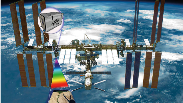
The ISS has a new colorful eye
The number of sensors in space for Earth environmental observation is growing. The International Space Station is an excellent point of observation for new technologies such as the DLR Earth Sensing Imaging Spectrometer (DESIS).
OBSERVING FROM THE ISS
Like many other satellites, the International Space Station (ISS) is occasionally visible to the naked eye as a bright point of light moving rapidly across the sky, and spotting it in the night sky is not an uncommon hobby. Reversing the point of view, the ISS is a unique platform for earth remote observation: being the only one with a human crew, its flexibility can lead to improved data acquisition for disaster response.
Modern technologies extend the capabilities of earth observation sensors beyond what an astronaut could record with a standard photographic equipment. One example is the use of imaging spectrometry, also known as hyperspectral remote sensing. Two imaging spectrometers are currently mounted on the ISS: the Japanese HISUI sensor expected to start nominal observation in the next months, and the DLR Earth Sensing Imaging Spectrometer (DESIS), installed in August 2018 by the astronauts and currently the only operative hyperspectral sensor on the station.
HYPERSPECTRAL EARTH OBSERVATION SENSORS
Imaging spectrometry measures the reflected solar radiation for a target on the Earth’s surface across a broad and finely sampled range of the solar spectrum. This means going beyond the limits imposed by the human eye in two ways: firstly, information can be acquired in the infrared range which is invisible to us; secondly, the intensity of reflected light which we perceive as a single color (say green light) can be further separated in several components. This way, the spectra observed from the sensor can be regarded by the machine as an incredibly high amount of « colors », which can be associated to the properties of targets on ground. As an imaging spectrometer, DESIS is therefore capable of identifying materials such as minerals in rocks and soils, mapping vegetation types and their health status, and monitoring the quality of water bodies and their constituents.
The mission is a cooperation between the German Aerospace Center (DLR) and the US company Teledyne Brown Engineering. The scientific community can task the DESIS sensor for free and access its whole archive until the end of the mission, by sending a short description of the envisaged use of the data to be reviewed by the DESIS science team.
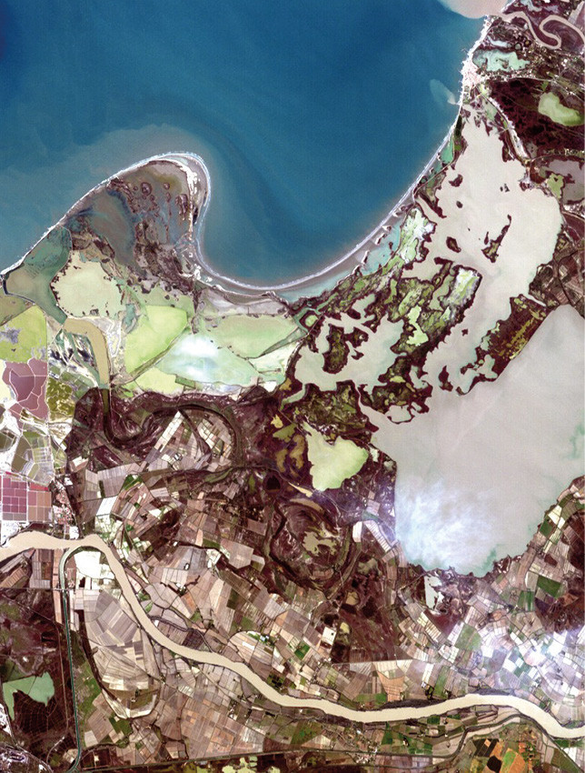 The Camargue as seen from DESIS |
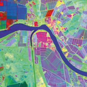
Detail showing differences in cropson aprocessed
subset of the Camargue image.
|
A LOOK ON THE CAMARGUE
In this example we show a DESIS image acquired on the Camargue, a natural region located south of Arles, France, between the Mediterranean Sea and the two arms of the Rhône delta. The small coastal urbanization of Saintes Maries de la Mer is visible on the top right. The area boasts a rich biodiversity, with the marshes dominating the area providing one of the few European habitats for the greater flamingo. Studies carried out in recent years using satellite images on the area include flood monitoring, phenological analysis of paddy rice, and agricultural classification.
Each pixel in the image is represented as a combination of different brightness of blue, green and red, simulating how a human would perceive the scene with his own eyes. But processing DESIS data can reveal many additional details about the differences in land cover within the area. As it is not possible to visualize at the same time all DESIS finely sampled spectral bands (which are more than 200), we can try to « compress » all the differences within the image using three synthetic bands. These are assigned to the red, green, and blue channels, with such « false colors » trying to exploit all the information in DESIS, including the infrared range. The resulting representation for a subset on the bottom left of the area appears very colorful, revealing a great variability in the types and characteristics of crops, as different colors represent different cultivations or differences within them, which can be subsequently more closely analyzed. Such differences are less obvious in the natural color image. On the other hand, pixels belonging to a more homogeneous ground cover class, such as the river, are represented with a similar color.
Daniele CERRA
is a research scientist with the Department of Photogrammetry and Image Analysis at the German Aerospace Center (DLR), Oberpfaffenhofen, Germany. He received the Ph.D. degree in image and signal processing from Télécom Paris in 2010. His research interests include imaging spectrometry and information theory.
 www.dlr.de/eoc/desktopdefault.aspx/tabid-13614
Auteur

Articles du numéro
-
- Editorial revue TELECOMEditorial revue TELECOM 2020, une année marquée par des évènements uniques et exceptionnels, chers fidèles lecteurs et...30 décembre 2020Lire la suite >
-
- Editorial LE NUMÉRIQUE dans le secteur de l'AÉROSPATIALEditorial LE NUMÉRIQUE dans le secteur de l'AÉROSPATIAL L’expérience de la troisième dimension et la conquête de l’espace ont toujours fasciné l’homme. Tout...30 décembre 2020Lire la suite >
-
- Autonomie et Aviation commercialeAutonomie et Aviation commerciale Autonomie ou automatisation ? La frontière est floue. Nous dirons que l’automatisation est le moyen...30 décembre 2020Lire la suite >
-
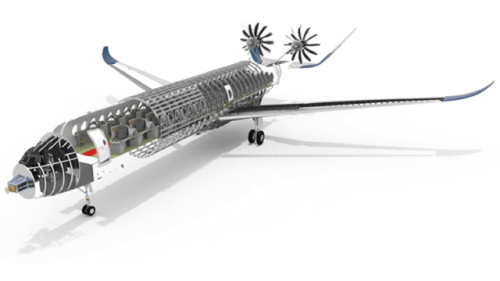
- Révolution digitale et aéronautiqueRévolution digitale et aéronautique L’apparition de l’informatique et sa généralisation rendue possible grâce aux progrès rapides de...30 décembre 2020Lire la suite >
-
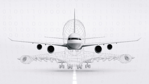
- Comment le virtuel a révolutionné l'industrie !Comment le virtuel a révolutionné l'industrie ! C’est en 1981 que la Société Dassault Systèmes a vu le jour. Une dizaine d’ingénieurs de Dassault...30 décembre 2020Lire la suite >
-
- Passer d'un concept cinquantenaire à une rupture technologique grâce au numériquePasser d'un concept cinquantenaire à une rupture... La réduction des émissions de carbone de nos véhicules (avions, automobiles, …) et de nos bâtiments...30 décembre 2020Lire la suite >
-
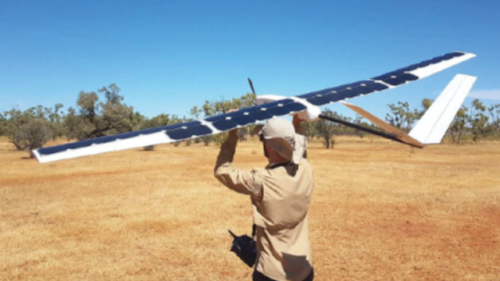
- De la traversée de la Manche au bush australien avec un drone solaireDe la traversée de la Manche au bush australien avec un... Interview de Laurent Rivière, président de Sunbird par Jean-Marie Pillot (1978)30 décembre 2020Lire la suite >
-
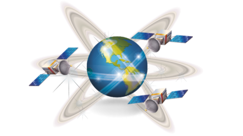
- Des Constellations de Satellites de Télécommunications toujours plus !Des Constellations de Satellites de Télécommunications... L’avantage des constellations de satellites se trouve dans la couverture mondiale, y compris des...30 décembre 2020Lire la suite >
-
- Les nouvelles bandes de fréquences pour les systèmes de télécommunications par satelliteLes nouvelles bandes de fréquences pour les systèmes de... Comment le satellite peut-il rester un complément des solutions terrestres afin de fournir un accès...30 décembre 2020Lire la suite >
-
- L'aéroacoustique numérique en aéronautiqueL'aéroacoustique numérique en aéronautique La prévision du rayonnement acoustique des aéronefs est indispensable pour agir dès le stade des...30 décembre 2020Lire la suite >
-
- Editorial Entreprendre dans les DEEPTECHEditorial Entreprendre dans les DEEPTECH De SimpleTech à DeepTech. La création annuelle de start-up dites Deeptech — centrées sur une avancée...30 décembre 2020Lire la suite >
-
- Faire de la France une puissance de premier plan en matière d'innovation de ruptureFaire de la France une puissance de premier plan en matière... Le plan deeptech traduit le potentiel de la France à davantage valoriser sa recherche, mais aussi...30 décembre 2020Lire la suite >
-
- De la French Tech à DeepTechDe la French Tech à DeepTech La France a, en quelques années, sous l’impulsion de l’État et de Bpifrance, fait émerger un...30 décembre 2020Lire la suite >
-
- La SATT Paris-Saclay, le lien entre les laboratoires et la création de start-up DeepTechLa SATT Paris-Saclay, le lien entre les laboratoires et la... Les Sociétés d’Accélération du Transfert de Technologie (SATT) sont un des acteurs de la...30 décembre 2020Lire la suite >
-
- Devenir un acteur majeur de l'innovation et de l’entrepreneuriat # 199Devenir un acteur majeur de l'innovation et de... Télécom Paris,au sein de l’Institut Polytechnique de Paris, a tous les atouts en main pour devenir...30 décembre 2020Lire la suite >
-
- Les profondeurs sont-elles hors de portée ?Les profondeurs sont-elles hors de portée ? QUELLES SONT LES DIFFERENTES CATEGORIES DE START-UP ? Manifestation d’un dynamisme entrepreneurial...30 décembre 2020Lire la suite >
-
- L'Entrepreneuriat Deeptech : le futur n'étant pas prévisible, construisons-leL'Entrepreneuriat Deeptech : le futur n'étant pas... Se risquer à formuler des prévisions dans le domaine du numérique présente inévitablement un risque....30 décembre 2020Lire la suite >
-
- DeepTech, l'hypolasie européenneDeepTech, l'hypolasie européenne Couplées aux grands investisseurs institutionnels, les sociétés de gestion opérant des fonds de...30 décembre 2020Lire la suite >
-
- Le financement des entreprises Deeptech de A à ZLe financement des entreprises Deeptech de A à Z ur scruté avec attention et éminemment stratégique, la Deeptech fait couler beaucoup d’encre. Nous...30 décembre 2020Lire la suite >
-
- Les leviers non dilutifs d'aide à l'innovation des entreprises de croissanceLes leviers non dilutifs d'aide à l'innovation des... Les aides publiques sont des outils souverains et défensifs dans un contexte de concurrence...30 décembre 2020Lire la suite >